Geography of Boavista Island
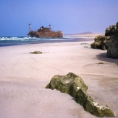
Of all the Cape Verde islands, Boavista is the closest to Africa, at just 567 km distance. It is also one of the Barlovento Islands (along with Sal and Maio). It has a surface area of 620 km2 and rises to 390 m at its highest point, Monte Estância. Sal Rei is the capital and is located in the northwest sector, overlooking the small islet of Ilhéu do Sal Rei, 1.8 km long and 0.7 cm wide. The coastline is very flat, with numerous sand dunes and golden beaches of organogenous sands. There are also broad stretches of stony flatlands, and a few hills and peaks, such as Monte Estância, Rocha Estância, Povoação Velha and Monte de Santo António, are dotted over the landscape. The only coastal cliffs of some size are found between Praia da Fátima and Ponta do Sol, and near Morro Negro. However, they are not sheer and the base is a platform of lava flows or debris. The longest sandy beaches are those of Curralinho (13 km) and Santa Mónica (11 km), on the south coast, and Costa de Boa Esperança, in the north. Boavista has a dry sunny climate and average annual rainfall does not exceed 275 mm; some years it does not rain at all. In contrast, the arrival of monsoon-like rains utterly transforms the landscape for a few weeks and the ravines run with water. Spots that have a permanent supply of fresh or brackish water are Ribeira de Água or Laguna de Rabil, and Olinho do Mar, located in the mountainous region in the east.


