
Madeira
The archipelago of Madeira lies on an oceanic crust aged 140 Ma (millions of years) and rises from a depth of 4000 m on the seafloor to Pico Ruivo, the highest point of 1862 m above sea level (on the island of Madeira). It is located at the southwest tip of a volcanic chain that, for the most part, is submerged, extends over 700 km and encompasses the Madeira-Desertas volcanic complex (0.1 to 5 Ma), and the seamounts of Porto Santo (11-14 Ma), Seine (22 Ma), Ampere (31 Ma) and Ormonde (67 Ma). This progression of ages is the result of the movement of a classic hotspot (the emission of volcanic materials from the mantle).
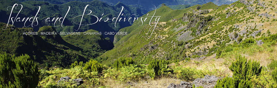
Madeira and the Desertas Islands are part of a single geological complex formed in four stages. Little is known of the first submarine stage, although it comprises roughly 95% of the total volume of materials. Submarine canyons are found on the south coast of the islands, descending from the littoral zone to 3440 m depth, alongside fields of cinder cones and sedimentary deposits, resulting from giant landslides on the flanks of both island edifices. A second stage took place at the end of the Miocene and during the Pliocene (4.6-3.9 MA) and corresponds to the submarine basement and oldest subaerial rocks. It consists of pyroclastic deposits and volcanic rifts, with small lava flows, locally sliced by dikes that form dense swarms in the central area of Madeira. The Desertas Islands emerged between 3.6 and 3.2 Ma, while volcanism was inactive in Madeira. The next stage occurred during the Plio-Pleistocene (3-0.7 Ma) and essentially consisted of alkaline basaltic lava flows that practically covered all the islands with a 500-metre-thick layer. The upper unit (post 0.7 Ma) consists of scoria cones and lava flows, resulting from a long period of intense erosion, mainly on the eastern flank of Madeira. The central zone of Madeira and the Desertas is characterized by dike swarms and steep dipping, numerous faults and a great many overlapping cinder cones. These structures lie parallel to the longest axes of Madeira (E-W) and the Desertas (NNW-SSE) and are characteristic of volcanic rift zones, such as the Canaries and Hawaii. The landscape of Madeira is characterized by extremely rugged terrain, dominated by calderas, deep ravines and ridges. From a geological perspective, one of the archipelago’s most characteristic areas is Ponta de São Lourenço, at the northeastern tip of Madeira, whose eastern flank faces the Desertas. The paleo-relief of the peninsula shows heavy erosion, which has resulted in a geomorphology of steep south-facing slopes, while the north coast is dominated by tall sheer cliffs. Basically, it is composed of basaltic pyroclastic deposits from phreatovolcanic eruptions crossed by numerous dike swarms.<0}
Porto Santo, which emerged during the Miocene, is located around 45 km northwest of Madeira, from which it is separated at a depth of 2000 km. The island is heavily eroded to the point that it now occupies only a third of its original surface, judging by bathymetric studies of the surrounding seabed. The northeast section of the island is composed of essentially submarine basaltic and trachytic lava flows, interspersed with levels of carbonatites deposited in shallow waters. In contrast, the western section of the island edifice was formed by a thin pile of alkaline basaltic lava flows associated with basaltic pillow lava. Both units are dissected by voluminous intrusions and basaltic and trachytic dikes, which shape most of the island’s ridges and pinnacles. On the western side of the island, the dikes are arranged in a northeast-southwest orientation, while on the eastern side they follow a radial pattern.
The archipelago of Madeira is situated around 700 km off the coast of Northwest Africa and some 500 km from the Canaries. Madeira (736 km2) is the main island and the largest, followed by Porto Santo (42.2 km2) and a group of uninhabited islets (14.5 km2), known as the Desertas (Ilhéu Chão, Deserta Grande and Bugio). The surface area of the archipelago totals 819.5 km2. Madeira is extremely mountainous, with imposing cliffs, deep ravines, erosion calderas and peaks to just below 2000 m, such as Pico Arieiro (1818 m) and the highest, Pico Ruivo (1861 m). The western half features the broad plateau of Paul da Serra, the biggest stretch of flatland on the island. Porto Santo is heavily eroded and comparatively much flatter than Madeira. The landscape is predominantly semi-arid and dominated by open plateaux. However, the northeast sector presents 200-metre-high cliffs and a group of peaks, including Pico do Facho, at 517 m the highest point on the island. Finally, the Desertas Islands are particularly striking because of their narrow shape, length and height, rising up like sharp ridges in the middle of the ocean. Deserta Grande is both the largest (10 km2) and the highest (478 m). The climate of Madeira is Mediterranean-like and mild, and strongly influenced by the Atlantic and trade winds. Average rainfall is around 600 mm, which is higher than in the Canaries and midway between that of the Canaries and the Azores, with by far the wettest climate. Temperatures, however, resemble those of the Canaries (with variations according to altitude), dropping to below zero, in the highest regions, in winter and early spring, and bringing frost and snow. In contrast, Funchal, which is south-facing, has a very similar climate to Santa Cruz de Tenerife.
A significant variation with the Canaries, at least in recent times, is the presence of permanent streams in several ravines on the main island, a clear indication that the climate of Madeira is much damper and wetter than that of the Canary Islands. A number of waterfalls cascade into the sea, especially along the north flank, something which has not been seen in the Canaries for many a decade.
Go Back