
Azores
The geology of the archipelago of the Azores is complicated for two reasons: volcanic origin and geotectonic location. The archipelago is the result of volcanic activity associated with the triple junction of the lithospheric plates of America, Eurasia and Africa. The islands emerge from the Azores Platform (from around 2000 m depth) to form a region of extremely rugged morphology, with a surface area of nearly 5.8 million km2. The structure is essentially a spreading centre, affected by several transform faults that extend in an east to west direction and associated with considerable seismic and volcanic activity.
The archipelago of the Azores is composed of nine islands and several islets, as well as numerous submarine volcanoes, arranged in a triangle and crossed by the Mid-Atlantic ridge. The westernmost islands (Flores and Corvo) are located on the North-American plate, which moves westwards, while the central (Terceira, Graciosa, São Jorge, Pico and Faial) and eastern islands (São Miguel, Santa Maria and Formigas) are aligned in a complex west-northwest to east-southeast orientation.
The Azores Platform was formed around 36 million years ago in association with a northward migration of the plate junction zone to its current position. Around 10 Ma, a thermal anomaly caused a hot spot that triggered a complex volcanic history. The Azores Platform is largely made up of volcanic alkaline basalts. The oldest isotopic ages obtained for subaerial materials from each island indicate that Santa Maria was the first to emerge, 8.12 Ma. Formigas, Terceira, Graciosa and Flores were formed during the Pliocene (between 4.65 and 2.15 Ma, respectively), and Faial, Corvo, São Jorge and Pico in the Quaternary (from 0.73 to 0.25 Ma). However, the ages of volcanism of the islands continue to be a matter of considerable debate.
Several recent studies, based on bathymetric, gravitational and seismic data, have put forward a new model to explain the formation of the Azores Platform. They suggest that this region is currently a narrow plate boundary that consists of several tectonic blocks situated between two fault systems. These faults establish the framework for the development of the volcanism that gave rise to the islands.
The geological evolution of the archipelago is similar to that of other Macaronesian islands in that periods of intense volcanic activity were followed by periods of erosion. On Santa Maria, the oldest island and the most studied from a stratigraphic perspective, the base of pre-Miocene sequence is composed of strata of submarine pyroclastic flows and subaerial scoria. On this base, alternate basaltic lava flows and thin deposits of pyroclastic sediment were laid down, between 5.7 and 8 Ma, and subsequently crossed by dikes, generated during fissure eruptions. During the Pliocene, sedimentary rocks with levels of breccia-like conglomerates, corresponding to alluvium deposits, were topped by a subaerial basaltic lava flow. These lava flows were covered by sedimentary levels and volcanic materials indicative of a marine environment and composed of fossiliferous calcarenites, conglomerates and submarine lava flows. During the Quaternary, a new sea-level transgression gave rise to an abrasion platform on which clays, sands, fossiliferous calcarenites and pebbles were deposited. Hydromagmatic edifices and trachytic domes appeared on some islands, such as Saõ Miguel, as a result of explosive volcanism.
In the last 500 years, there have been 28 historical eruptions, mainly along the Terceira Rift and on Saõ Miguel, Terceira, Saõ Jorge, Pico and Faial; the best recorded event occurred at Capelhinos (Faial) in 1957. Also as a result of a geotectonic framework, the Azores have experienced intense, low-magnitude seismic activity.
Unlike the other archipelagos of Macaronesia, the Azores show a limited development of old sedimentary rocks, most of which are marine in origin. Moreover, the fossil record is almost entirely given over to marine fossils, with very few references to terrestrial sites. Santa Maria is the best studied with fossiliferous deposits ranging from the Miocene-Pliocene to the Pleistocene, generally corresponding to horizontal levels of limestone, sandstone, conglomerates and breccia, interspersed between volcanic materials. These deposits are usually 3-4 m thick and located at different heights (up to 400 m) above sea level.
A rich fossil fauna has been recorded at the Miocene marine sites on Santa Maria, including benthonic and planktonic foraminiferans (Cibicides, Planurbulina, etc.), which points to an environment of warm shallow waters. A considerable number of species of gastropods, bivalves, echinoderms, bryozoa and crustaceans is also listed, indicating that they may be Upper Miocene-Lower Pliocene deposits (7-5 Ma). The remains of cetaceans (Mesoplodon sp.) and sharks (Carcharodon sp.) have also appeared at these sites.
Subsequently, in the Upper Pleistocene, new marine sites of raised beaches were formed, now exposed at 2-3 m asl. Fauna also abounded in these deposits, particularly molluscs. Among them are several species no longer present in the Azores because oceanographic conditions have changed and they correspond to a time when the water temperature and ocean currents facilitated the arrival of tropical species (Cypraea picta, Polinices lacteus, etc.).
Although terrestrial fossils are known to be scarce, there are some records of fossilized plant remains on Terceira, Faial and Pico, which were found among volcanic tuff materials. These fossils are impressions of plant leaves and stalks (Asplenium, Juniperus, Picconia, etc.). What is extraordinary is the total absence of records mentioning sites of terrestrial gastropod remains, so common to the rest of Macaronesia.
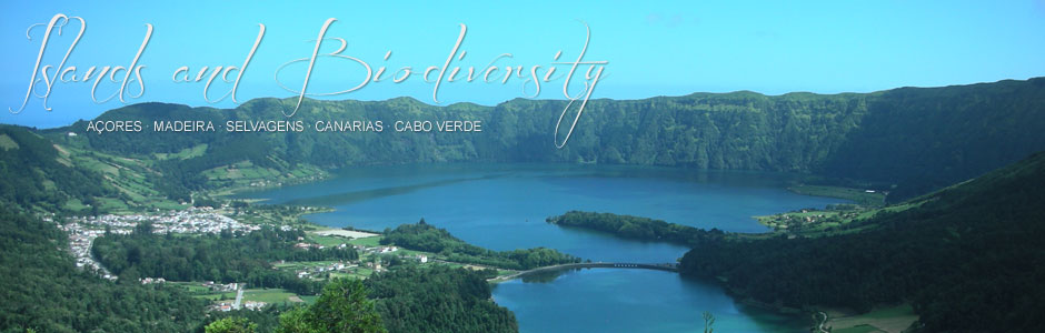
The archipelago of the Azores is located at some 1380 km from Portugal and is made up of nine islands, arranged in three groups: the eastern isles of Santa Maria and São Miguel, the central isles of Terceira, São Jorge, Graciosa, Pico and Faial, and the western isles of Flores and Corvo. The latter two are located on the American tectonic plate (not the European like the rest) and are much closer to the American continent, at 1930 km distance from Newfoundland (Canada). São Miguel (757 km2), the capital, is the largest island, while Corvo (17 km2) is the smallest. The total surface area of the archipelago amounts to 2344 km2 and the highest peak is found on the island of Pico (2351 m).
The recent origins of most of the Azores accounts for the near total absence of deep ravines, except in the east of São Miguel, one of the oldest parts of the archipelago. However, important coastal cliffs feature on all the islands, as do large calderas (particularly on São Miguel, Terceira, Faial and Flores), almost always with natural lakes, and alignments of recent volcanoes or cinder cones, which are clearly visible on São Jorge and Pico. The large central volcano on Pico, a stratovolcano like Mt Teide (Tenerife), is particularly interesting because of its size and appearance, as is Pico Novo, on Fogo (Cape Verde), although it lacks the surrounding caldera of the previous two.
The climate of the Azores is very peculiar, a fact that is suitably reflected in the name of the anticyclone that frequently affects Europe. The Azores have by far the highest rainfall of all Macaronesia, with an annual average of around 4000 mm (e.g., on Flores), more than 1000 mm difference compared with the highest recorded values for Madeira and three times higher than those registered in the Canaries. In any case, the annual average for the entire archipelago varies from 1000 to 1600 mm at sea level. Relative humidity is also very high and can reach 95% in certain areas. The sun index, however, is rather low, since the annual average number of sunny days does not exceed 73 on the two easternmost islands, despite their privileged geographical location. The sea temperature is higher than would be expected for the latitude of these islands, thanks to their geographical position, directly in the path of the warm waters of the Gulf Stream.
The marine environment of the Azores is influenced by the Azores High (or anticyclone) and the Gulf Stream, which transports relatively warm waters through this ocean zone. These islands are particularly interesting from a biological and biogeographical perspective, given their recent age and isolated position in the middle of the Atlantic.
Go Back